[et_pb_section admin_label=”section”][et_pb_row admin_label=”row”][et_pb_column type=”4_4″][et_pb_text admin_label=”Text” background_layout=”light” text_orientation=”left” max_width=”900″ text_font_size=”15″ use_border_color=”off” border_color=”#ffffff” border_style=”solid”]
Conservation and Management of
Maldivian Mangrove Habitats – Baseline Study
Haa Dhaalu NEYKURENDHOO
Table of Contents
2 Introduction
3 Overview of the island and social setting
3.1 Population and housing stats
4 Ecological Setting
4.1 Overview
4.2 Flora
4.2.1 Rhizophora apiculata (Thakafathi)
4.2.1 Lumnitzera racemosa (Burevi)
4.2.2 Bruguiera cylindrica (Kan’doo)
4.2.3 Floral abundance and diversity
4.3 Fauna
4.3.1 Overview
5 Threats
5.1 Climate change
5.2 Anthropogenic
5.2.1 Existing
5.2.2 Potential
2 Introduction
Mangroves are woody plants that grow at the interface between land and sea in tropical and sub-tropical latitudes where they exist in conditions of high salinity, extreme tides, strong winds, high temperatures and muddy, anaerobic soils. There may be no other group of plants with such highly developed morphological and physiological adaptations to extreme conditions.
Mangrove forests occupy about 15 million hectares of tropical and subtropical coastline worldwide.
Although they amount to only 1 per cent of the total area of tropical forests, mangroves are highly productive ecosystems rich in biodiversity, consisting of a wide variety of plant species that provide important habitats for a wealth of fauna, including mammals, birds, reptiles, fish and molluscs. They contribute to livelihoods locally and globally by providing forest resources such as timber, firewood and thatching materials as well as non-timber products. Mangroves are also recognized as an important greenbelt and carbon sink that protects coastal areas from natural disasters such as tsunamis, cyclones and erosion resulting from sea-level rise, especially in small island countries.
Mangroves create unique ecological environments that host rich assemblages of species. The muddy or sandy sediments of the mangal are home to a variety of epibenthic, infaunal, and meiofaunal invertebrates. Channels within the mangal support communities of phytoplankton, zooplankton and fish. The mangal may play a special role as nursery habitat for juveniles offish whose adults occupy other habitats (e.g. coral reefs and seagrass beds).
As the mangroves are surrounded by loose sediments, the submerged mangroves’ roots, trunks and branches are islands of habitat that may attract rich epifaunal communities including bacteria, fungi, macroalgae and invertebrates. The aerial roots, trunks, leaves and branches host other groups of organisms. A number of crab species live among the roots, on the trunks or even forage in the canopy. Insects, reptiles, amphibians, birds and mammals thrive in the habitat and contribute to its unique character.
Living at the interface between land and sea, mangroves are well adapted to deal with natural stressors (e.g. temperature, salinity, anoxia, UV). However, because they live close to their tolerance limits, they may be particularly sensitive to disturbances like those created by human activities. Because of their proximity to population centers, mangals have historically been favored sites for sewage disposal. Industrial effluents have contributed to heavy metal contamination in the sediments. Oil from spills and from petroleum production has flowed into many mangals. These insults have had significant negative effects on the mangroves.
Maldives is known for its coral reefs and beaches; mangrove ecosystems in Maldives are over-shadowed by these environments and oftentimes neglected and under constant anthropogenic threats despite its crucial ecological and geomorphological function to this small island nation.
This study aims at establishing a baseline of environmental conditions of significant mangrove habitats throughout the country. Data and information collected via this study will provide a foundation for conservation efforts to build upon and help future environmental monitoring of said environments.
3 Overview of the island and social setting
3.1 Population and housing stats
HDh. Neykurendhoo is located towards the centre of HDh. Atoll at 6°32’34.95″N and 72°58’49.52″E. With a land area of 169.3 ha, the island is among the larger islands of the atoll. Community of Neykurendhoo, 750 people as per Census 2014, accounts for 3.91% of the total atoll population; with an estimated population density of 4.43 people per ha. Based on recorded populations in 2006 and 2014 during Census, inter-census average annual growth rate of the community was found to be -1.93.
The island is characterized by a relatively small lagoon with the island almost entirely covering the reef. The circular shape of the island is typical of islands found in the center of the atolls; even currents shaping the island during two monsoons. 31.03ha of the island is currently utilized for residential purposes; extending form the northern tip and inland.
4 Ecological Setting
4.1 Overview
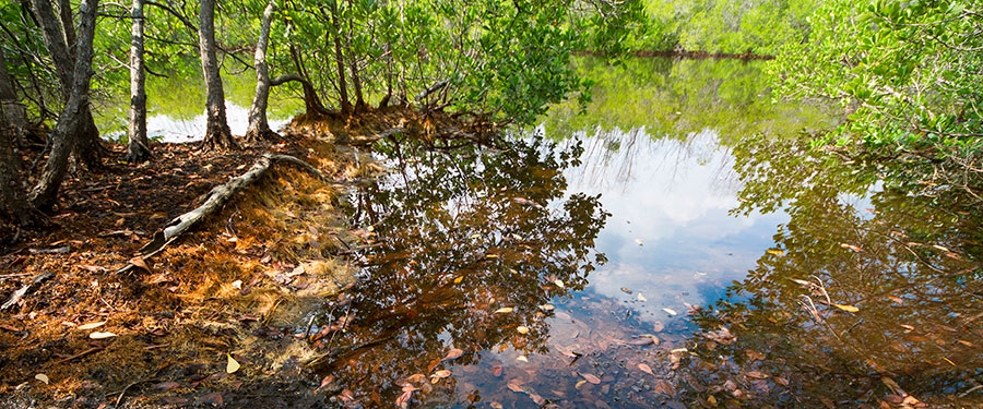
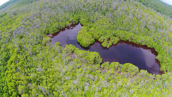
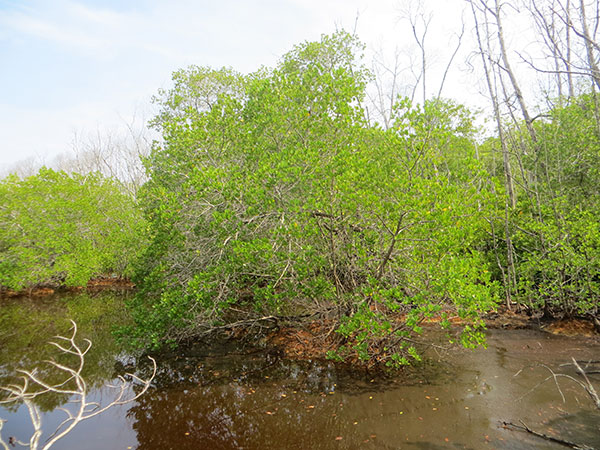
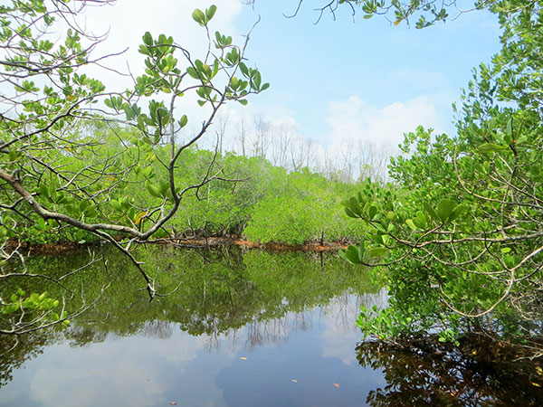
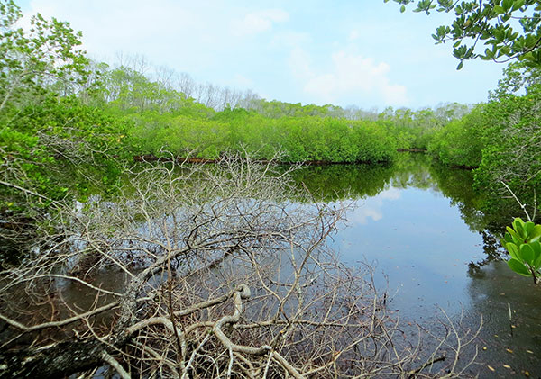
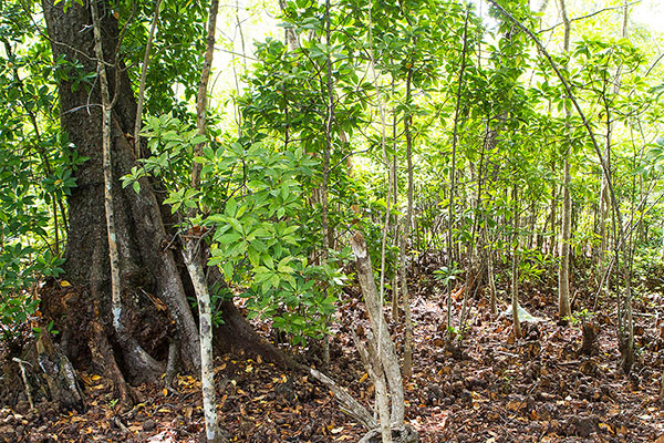
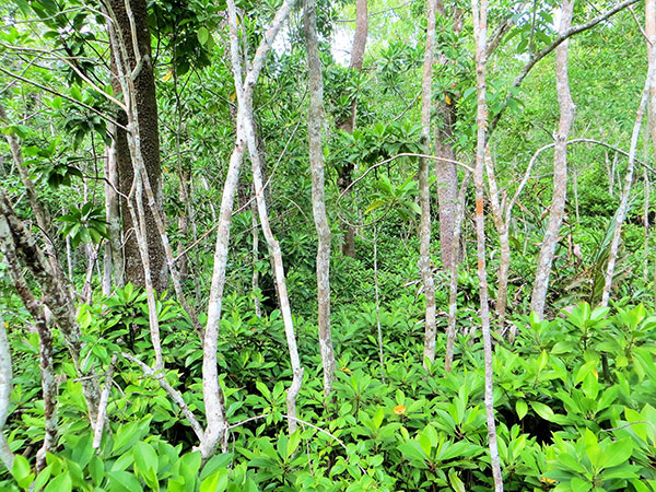
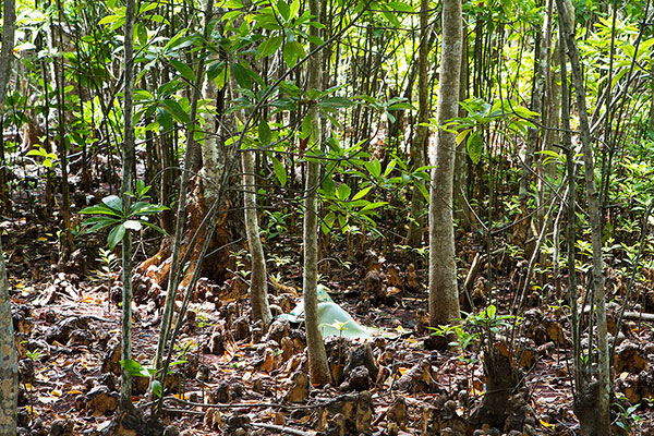
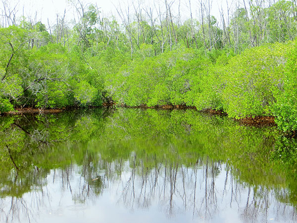
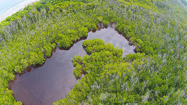
The wetland area of Neykurendhoo is continuous on the eastern side of the island; majority of the wet land area is inaccessible due to thick vegetation. The entire wetland is estimated to cover an area of 28.3ha; 16.7% of the whole island. Two separate water bodies can be found within the wetland area, the larger of the two (Site A) measuring about 0.32ha while the smaller one is estimated to be 0.11ha. It should be noted, these two are expected to grow during wet season with heavy rainfall and shrink during the dry season. The entire wetland area is covered by mangrove fauna as far as the survey could determine.
As far as the water quality of the sites are concerned; the two water bodies were found to contain freshwater (1.1ppt). Decaying plant matter and fine sediments were found suspended (in water column) in great concentrations at all the sites; leading to high TSS values. Typical values from onsite measurements range from 50NTU to 100NTU for turbidity while TSS readings were found to range between 42mg/l to 81mg/l.
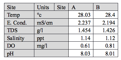
Table 4‑1: Water Quality readings
Both sites had an estimated water depth of 0.3 to 1m at MSL. However, it should be noted; due to high amount of lose sediment and organic matter settled at the bottom, it is hard to quantify water depths accurately.
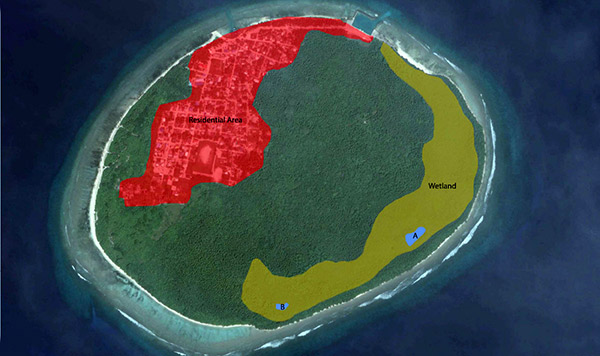
Figure 4‑1: Wetland Areas and general landuse of HDh Neykurendhoo
4.2 Flora
Four species of mangrove plants were found in Nykurendhoo during the field survey; Lumnitzera racemosa (Black mangrove- Burevi), Excoecaria agallocha (Milky mangrove- Thela),Bruguiera cylindrica (small- leafed orange mangrove- Kandoo) and Xylocarpus moluccensis ( Puzzle Nut tree/Cannonball tree- Marugas).
1.1.1 Lumnitzera racemosa (Burevi)
| Scientific Name: | Lumnitzera racemosa |
| Common Name: | Black Mangrove |
| Conservation status: | Currently categorized as of Least Concern according to the IUCN Red List of Threatened Species. |
| Habitat: | Usually restricted to the landward edge of open mangrove forests, Lumnitzera racemosa is found along coastal shores, lagoons, saltwater and freshwater swamps, swampy meadows and in sandy soils |
| Key Uses: | The timber is used in salt water piling and fencing. It is also used for house posts, boat building and as firewood. |
| Abundance: | Fair |
| Taxonomy | |
| Class: | Eudicots |
| Order: | Myrtales |
| Family: | Combretaceae |
| Genus: | Lumnitzera |
Morphology:
Its tree bark is brown colored and ‘knee roots’ are often formed through the extension of the curved aerial roots. The leaves, which are alternately arranged and emerald-colored, grow in clusters at the tip of the branch. The leaf margin is wavy with small serrations. The obovate leaf is either round or caved at the front, similar to a mullet roe. The flower has five white-colored petals and there are two blooming periods each year. The first flowering period occurs between May and July, while the second time occurs between October and November. The fruits of Lumnitzera racemosa are drupes, whose endocarp is solid and expcarp is similar to that of a sponge. This allows the fruit to float on the water surface and be distributed through water dispersal. Lumnitzera racemosa is the most salt-tolerant tree species amongst the mangrove plants. Its roots develop into ‘knee roots’, which provides stability.
4.2.1 Bruguiera cylindrica (Kan’doo)
| Scientific Name: | Bruguiera cylindrica |
| Common Name: | Small-leafed Orange Mangrove, Reflexed Orange Mangrove |
| Conservation status: | Currently categorized as of Least Concern according to the IUCN Red List of Threatened Species. |
| Habitat: | This species is found in downstream and intermediate estuarine zones in the mid-intertidal region. This species is also shade tolerant. |
| Key Uses: | Fruit is used for human consumption while timber is sometimes used as firewood. |
| Abundance: | Very high |
| Taxonomy | |
| Class: | Eudicots |
| Order: | Malpighiales |
| Family: | Rhizophoraceae |
| Genus: | Bruguiera |
Morphology:
Bruguiera cylindrica is a columnar tree growing to 23 m high. It has finely fissured, greyish bark. There are short buttresses at the base of the trunk and small, knee-like air-breathing roots (pneumatophores).
The leaves are simple, opposite, thin and glossy green, elliptic in shape, 5 – 17 cm long, 2 – 8 cm wide, with a bluntly pointed apex. The leaves occur in clusters at the end of branches. The petiole is often reddish and 1 – 4.5 cm long.
The inflorescence is often three-flowered and axillary. Flowers have a pale-greenish calyx with 8 calyx lobes, 16 stamens and 8 white, bi-lobed petals with 2 – 3 bristles on each apex and 1 conspicuous bristle in the sinus (indentation between the petal lobes) that is longer than the petal lobes. The viviparous propagule grows from within the calyx and is pencil-like and green, with a smooth surface. It is 8 – 15 cm long and 0.4 – 0.8 cm wide.
1.1.1 Excoecaria agallocha (Thela)
| Scientific Name: | Excoecaria agallocha |
| Common Name: | Milky Mangrove, Blind-your eye Mangrove, river poison tree |
| Conservation status: | Currently categorized as of Least Concern according to the IUCN Red List of Threatened Species. |
| Habitat: | This is a back mangrove species and often exploits open areas and is tolerant of disturbed areas. |
| Key Uses: | This species is used for furniture and ornaments. In Papua New Guinea it is used for pain relief from fish stings. It is also used as a poison to catch fish. Used in traditional medicine and also as firewood. |
| Abundance: | Low |
| Taxonomy | |
| Class: | Eudicots |
| Order: | Malpighiales |
| Family: | Euphorbiaceae |
| Genus: | Excoecaria |
Morphology:
The tree grows to 15m tall sometimes branched at the base, thus forming multiple trunks. Roots run along the ground surface and often knotted and covered with lenticels. The tree does not have root systems obviously specialized for mangroves and that it is also found to an elevation of 400m and thus cannot be regarded as an exclusively mangrove tree. The tree bark is grey, smooth but warty, becoming fissured. Lenticels are prominent on young twigs.
Leaves are thick, oval and pointed (5-10cm long), arranged alternately in a spiral. Young leaves are pink, old leaves turn yellow then red before dropping off. Leaves usually drop off after dry weather.
Flowers are tiny (less than 1mm). Trees bear either male or female flowers, never both. Male flowers start as upright narrow cones when young and as they develop, elongate into longer spikes (5-10cm) that eventually form drooping yellow tassels. Female flowers appear in shorter spikes.
The fruits are small (less than 1cm) three-lobed, green turning black as they ripen into dry capsules. Each capsule is made up of three portions, containing tiny dark to black seeds.
4.2.2 Floral abundance and diversity
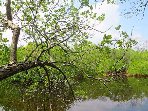
Wetland area of Neykurendhoo was dominated by Bruguiera cylindrica; Kan’doo; seedlings to mature trees towering over 20m of this species were seen throughout the wetland area. On average, a 30m by 30m area would have B. cylindrica 100+ juvenile trees (height below 1m), 20 trees between 2 and 5m height and at least one tree over 5m height. Few Excoecaria agallocha trees were sighted throughout the wetland area though low in abundance. Lumnitzera racemosa were only seen around the waterbody marked as Site A. The L. racemosa belt was seen to extend up to 30m from waterbody at site A. Overall, the flora of wetland area in Neykurendhoo can be said to be low in biodiversity and species richness, though it has one of the largest population of B. cylindrica reported in the Maldives.
4.3 Fauna
4.3.1 Overview
A fair amount of mangrove fauna, mostly crustaceans were sighted in Neykurendhoo wetland areas.
Crustacea
In many mangroves a large proportion of the leaf litter is directly consumed by crabs, particularly those in the family Sesarmidae. This dramatically accelerates the incorporation of mangrove biomass into the food chain. The acceleration happens in three main ways:
1. Shredding – as crabs feed on leaf litter they shred it into fine particles, increasing the surface area for leaching and microbial colonisation. An Australian study found that 20% of the material processed by crabs is dropped without being ingested (Camilleri 1989), but even this is shredded into fine particles.
2. Accelerated leaching – 85% of the leaf litter ingested by crabs ends up in faeces. Processing of this material in the crab gut reduces content of unpalatable tannins in faeces to less than 3%, compared to 13% in freshly fallen leaves (Lee 1998). This process means that decomposing microbes can colonise the processed leaves in hours or days, rather than the weeks required without crabs.
3. Assimilation – around 12% of the leaf litter processed by crabs is assimilated as crab biomass. A range of predators then feed on these crabs, including a number of fish species that are of high importance to fisheries (Sheaves and Molony 2000).
Additionally, crabs will invest a proportion of the energy assimilated in reproduction, producing large numbers of crab larvae which are an important food source to smaller predators.
Estimates for the amount of litter consumed by crabs vary. In many mangroves, crabs play a major role: one Australian study found that 70% of Bruguiera leaves and 88% of Ceriops leaves were taken down crab burrows in an Australian mangrove, and those left on the surface were eaten by crabs where they fell (Robertson and Daniel 1989b). Similar results have been found in Brazil, where the crab Ucides cordatus was found to consume 84.2% of the total daily litterfall (Nordhaus et al. 2006).
5 Threats
5.1 Climate change
Among the predicted outcomes of climate change, the most pronounced effect is sea-level rise due to global warming. Mangrove systems do not keep pace with changing sea-level when the rate of change in elevation of the mangrove sediment surface is exceeded by the rate of change in relative sea-level. The understanding of mangroves as opportunistic colonizers with distribution controlled through ecological responses to environmental factors highlights the importance of the geomorphic setting in determining where mangrove ecosystems establish, their structure and functional processes. An understanding of a mangrove’s geomorphic setting, including sedimentation processes (sediment supply and type), hydrology, and energy regime, is likewise important in understanding resistance and responses to changes in sea-level, as these affect both surface and subsurface controls on elevation of the mangrove sediment surface.
5.2 Anthropogenic
5.2.1 Existing
Due to lack of accessibility into the most parts of wetland area, not much alterations to its natural status were made by the community. However, some amount of deforestation in parts of the wetland were seen; fairly uncommon. It is believed large mangroves were cut down for timber by locals. Overall, anthropogenic threats to the wetland is minimal at this island.
5.2.2 Potential
If harvesting mature mangroves for timber is not managed and regulated well, there is potential for significant loss of vegetation and cause irreversible environmental damage to the wetland area.
[/et_pb_text][/et_pb_column][/et_pb_row][/et_pb_section]