DHUVAAFARU: ONE OF THE MOST VULNERABLE ISLANDS TO CLIMATE CHANGE
When the fishermen of Kandholhudhoo in Raa Atoll returned to their island on 26 December 2004, they were shocked to see a destruction that was difficult to describe. Debris from collapsed houses and destroyed buildings were scattered everywhere. They had not seen the deadly wave of destruction that hit the island in the morning. Most of those who witnessed the horror, those who frantically swam for their lives in the waters, had already left, in boats from other islands which had arrived for rescue. Clueless about what had hit their island, and the whereabouts of their family members, the fishermen set out in their boats, searching for loved ones.
This was how life began for the people of Kandholhudhoo as internally displaced persons (IDPs), scattered in five different inhabited islands of Raa Atoll, living in temporary shelters. They would stay in makeshift tents for four years, till December 2008, when they were resettled in Dhuvaafaru, an uninhabited island, which was built from scratch by the International Federation of Red Cross and Red Crescent Societies (IFRC).
Kandholhudhoo
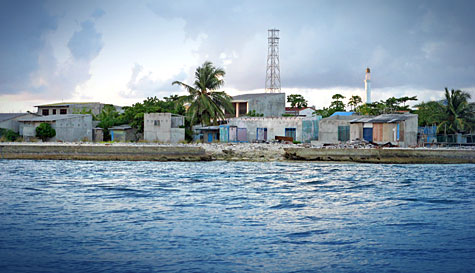
In Kandholhudhoo houses were located within ten feet from the sea, and without the protection of the house reef, the island lay like a ticking bomb.
Among the islands of Raa Atoll, only Kandholhudhoo, located on the western edge of the atoll, was badly hit by the Indian Ocean tsunami of December 2004. However, the island had suffered monsoon flooding and swells even prior to the tsunami. Kandholhudhoo was an extreme case of population congestion, with more than 3,000 people living in a tiny speck of land with only 150 meters in width and a land area of merely 4.4 hectares. Life in the island was inhospitable even back in 1990s. However, the people refused to settle elsewhere, because of the island’s proximity to good fishing grounds and various other socioeconomic factors. An economy based on traditional fishery and sea cucumber fishery thrived on the island. Young fishermen often scuba dived recklessly, surfacing too fast with sea cucumbers, impatient to go for another dive to pick more sea cucumbers from depths below. However, as the lure of a quick buck increased the cases of decompression sickness, life went on in Kandholhudhoo, and people continued to walk in the island’s narrow lanes – some barely enough for a person to walk, and some too narrow for a coffin to be carried – and new buildings sprouted from the income earned through fishery.
Reclamation
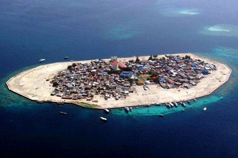
The large population pressure had led to the reclamation of the coastal area of Kandholhudhoo in all directions beyond the local reef, making the island more vulnerable.
The island became first vulnerable to monsoon floods and swells due to a combination of factors including a reclaimed shoreline and a mined reef. To find a temporary solution to the high population pressure on this island, the previous government gave in to the demands of the islanders by allowing the reclamation of the coastal area in all directions beyond the local reef, known as the “house reefâ€. Houses were located within ten feet from the sea, and without the protection of the house reef, the island lay like a ticking bomb. The occasional swells and flooding could have been warnings of an inevitable doom.
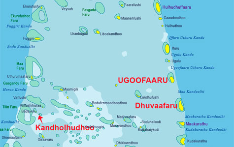
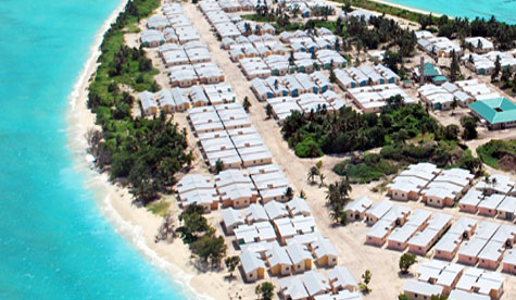
Dhuvaafaru
Dhuvaafaru, literally meaning “running reef†in local language Dhivehi, was an uninhabited island in the eastern edge of Raa Atoll. In reality the reef is not moving but the island has got very dynamic beaches and the shape of the island changes frequently.  While the reef remains in its original location, the shifting beaches and variations in the shape of the island during different seasons must have led to local fishermen to name the island as a moving reef.

Dhuvaafaru as an uninhabited island in the eastern edge of Raa Atoll.
Seasonal variations in the shape of beaches and shoreline are not a new phenomenon in the Maldives. In fact, in most islands of the Maldives, the forces of erosion and deposition, along with variations in ocean currents and wind, based on the Monsoon, causes the location of beaches to shift. The location of a large white sandy beach during northeast monsoon may turn into a lagoon in the southwest monsoon, while the beach is formed in another part of the island. In Dhuvaafaru, the forces of nature were at work more intensely, making the island very dynamic.
Bad Choice
Dhuvaafaru project has been the largest single post-tsunami reconstruction project in the Maldives and one of the biggest in the IFRC’s history by developing an island community on 49 hectares of low-lying uninhabited coral island in the Maldives. The IFRC has built 600 new houses and other amenities, using donations from the American, Finnish, and German Red Cross societies, and at a cost of 35.6 million Swiss francs.
However, proper consultation was not made with the island community of Kandholhudhoo before the decision was made to resettle them in Dhuvaafaru. Officials of the former government had a minimal consultation with the island community while the people were traumatized by the tsunami. Moreover, proper studies were not made on the topography and geomorphology of the island before it was selected.
Dhuvaafaru is one of the lowest islands in Raa Atoll with a height of less than a meter. Moreover, not less than one third of a meter from the top soil of Dhuvaaafaru has been removed in leveling the land surface, further lowering the island’s height during the construction of infrastructure.
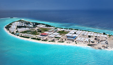
Dhuvaafaru is one of the lowest islands in Raa Atoll with a height of less than a meter above sea level.
At the end of her official visit to Maldives (18-25 February 2009), the United Nations Human Rights Council’s Special Rapporteur on Adequate Housing, Ms. Raquel Rolnik, pointed out a number of concerns, such as allotment of resources by some international donors and their administration by the Maldivian authorities, which was not done as competent as it could have been. “In the new resettlement sites that I visited, I detected a lack of participation in the decision making process concerning relocation, the design of the new houses, and the infrastructure, which resulted in new structures that were not always compatible with the livelihood of the communities”.
Dhuvaafaru is an example of the type of new resettlement where there was not sufficient community participation in the decision-making process. The traumatized people were in need of a new home, and they were willing to go anywhere. The government officials, by choosing Dhuvaafaru, made an impractical decision as Dhuvaafaru is a relatively small island and would not cater to an expanding population. The people of Kandholhudhoo, after suffering from population congestion and land scarcity, would encounter the same problems within a few decades in Dhuvaafaru. Some government officials and even a few islanders seemed to envision a solution in the pristine lagoon of Dhuvaafaru. They were hoping to reclaim the lagoon and find new land, even though such an expansion would make the island even more vulnerable. Land reclamation had been one of the favoured solutions of the previous government, whether it was to ease population congestion, for developing new resorts, or even for waste management. No lessons seem to have been learned from the example of Kandholhudhoo.
Bleak Future
The United Nations Intergovernmental Panel on Climate Change (IPCC) has recently projected in its latest report a rise of the sea level worldwide by two feet by 2100 as a result of melting ice sheets and the expansion of the sea by warming seawater. If the IPCC projection is accurate, Dhuvaafaru would be among the first islands to be affected by rising global sea level. Dhuvaafaru is promoted as a ‘safer island’. It is ironic that such a comparatively low island was selected to house tsunami refugees.
There is historical evidence that people lived in Dhuvaafaru some 200 or 300 years ago. In the famous tale of Mohamed (Bodu) Thakurufaanu who saved the Maldives from Portuguese in 16th century, his compatriot Dhandehelu hails from Dhuvaafaru. Elderly people from Kandholhudhoo claim their ancestors lived in Dhuvaafaru. Some even say the tombstones of their forefathers had inscriptions with references tracing the origins of the family to Dhuvaafaru.
Dhuvaafaru was abandoned by its last inhabitants due to erosion. The people of the Maldives had always lived at the mercy of the forces of wind, water, and salt. Erosion is not a new phenomenon. Historians and geographers, who had visited these islands centuries ago, had chronicled the migration of the island communities from one island to the other because severe erosion, abandoning islands and taking with them their belongings including even trees. This had been first documented by Arab geographers Abu Zayd of Siraf in 890 A.D. and Al Biruni in 1030 A.D. Hence, it is probable that the people living in Dhuvaafaru left the island and settled in Kandholhudhoo due to its proximity to rich fishing grounds.
If that had been the case, history seems to be on a reversal, as the descendants of those people return to Dhuvaafaru, not because of erosion, but after being refugees of the tsunami triggered by a submarine earthquake off the coast of Sumatra in December 2004. It will be an irony of history, if the descendants of the current settlers are forced to abandon Dhuvaafaru, due to climate change, erosion and rising sea levels in the not too distant future.
Futtaru Faraiy said,
March 3, 2009 @ 5:02 pm
thank you Bluepeace for another interesting blog post. However, Mariyam Omidi of Minivan News, in her news article of 3 March 2009 (A Symbol of Hope), paints a different picture of Dhuvaafaru:
“Relocating 4,057 people to a new island community built from scratch was no mean feat. Nor was the island arbitrarily selected as some suggest it was. Dhuvaafaru was chosen for its size, location and large house reef which provides a natural protective barrier against the ravages of wind and sea.”
Interestingly neither Minivan News nor Bluepeace give sources and further references on the process through which Dhuvaafaru was selected for resettlement of Kandholhudhoo IDPs. So we are torn between which news source to believe, as both Bluepeace and Minivan News generally report well-research and fact-based articles.
Was Dhuvaafaru chosen for its size, location and large house reef which gives protection as Maryam Omidi writes, or was it chosen without a concrete EIA, and not considering the “topography and geomorphology” as Bluepeace claims?
Bluepeace has tried to convince the readers that Dhuvaafaru is not viable based on a history of erosion and owing to the fact that the island is very low-lying. But can this fact be negated by the large house reef?
Both Bluepeace and Minivan News agree that there was no proper consultation with the community before the project was started. If so, who started this project? Who made the decisions?
Bluepeace says the island is too small to sustain a growing population within a few decades. Minivan News feels one of the reasons why the island was selected is “size”. Which brings us to the interesting question. When will the land in Dhuvaafaru be full? Within 20 years? 30 years? If so, is the cost worth it?
I am desperate for answers.
Ismail Fulhu said,
March 4, 2009 @ 2:44 am
“One teenager told me Dhuvafaaru was “bigger†than their former island Kandholhudhoo, Raa atoll, and the houses, “betterâ€. Even as I pushed each person I spoke to, to share their grievances about the island with me, the most common response consisted of the words “happy” and “very happy”.” _Minivan News
http://minivannews.com/politics_detail.php?id=6105
Almost any island in Maldives must be bigger than Kandholhudhoo because Kandholhudhoo can’t be much bigger than a football stadium. The refugees were even saying while they stayed in tents that the tents were better than their houses in Kandholhudhoo. No wonder they think Dhuvaafaru is bigger and houses better.
m.mohamed said,
March 9, 2009 @ 9:33 pm
Where were you with this very important information when than the government took decision t relocate the tsunami victims to such a vulnerable island. Have you done your duty as an environmental protection organization by informing the danger facing the people who were going to relocate to this island.
Ibrahim said,
March 10, 2009 @ 5:51 am
there is no single solution to the Maldives in the face of climate change projections of IPCC. Its an irony for us to believe in safer, islands. it may be safer than others but equally vulnerable as well. reclamation is used as the magic bullet to provide a temporary solution to land scarcity in islands, but its the worst decision one could make interms of longterm survival of our islands.Meanwhile relocation to bigger islands and utilising the land better is the only way to combat future impacts of climate change and associated risks. I have been advocating the building of flats instead of slicing the islands like a cake. Giving land plots is the worst kind of decision to combat land scarcity. we need to use space above as there is no horizontal space except the sea. Hence vertical development is the only solution to land scarcity and the only way to deal it is building flats.in a country with 99% water and a population density of 300 per square kilometre and having the most vulnerabale geomorphology in the face of climate change our future is bleak. We cant go on reclaiming all the reefs as the only chance of reef survivial is through protection of them from anthropogenic effects. If not the synergisitc effects of climate change and anthropogenic stresses will kill all our reefs which are the building blocks of the entire nation. There are only five countries in the World made entirely of atolls and we have the biggest challenge of them all as we have the highest population density. So lets do as much as we can to protect the reefs as reefs need resilience and resistant in the face of climatic threats. The inconvininet truth though is our life styles is increasing the burden on the environment. Why cant we make Male a place free from motorcycles for gods sake.Who needs a motor bike like a fish needs one.
Ibrahim said,
March 10, 2009 @ 6:34 am
we are still not familair with the word social impact assesment, though we have a sceptical EIA tradition. It is high time we realise that for each and every major decision we need to do a social impact assesment as part of EIA or seperate from EIA.Major decisions made recklessly in an adhoc manner has hampered all major development projects undertaken in the past.no matter whether it is building harbours, schools or hospitals or relocating people or mitigating disasters.We are doing it still the traditional Maldivian method, top down, adhoc decisions. I hope the curent government puts more effort in assesment studies before major decisions.
ahmed fulhu said,
March 10, 2009 @ 11:28 am
raise no concern now just give next solution,so to take action before it is too late.
Naimbe said,
March 11, 2009 @ 10:56 am
Thank you BP for this very interesting and informative article. Your article has further reinforced my conviction on population consolidation in the Maldives. I did a brief blog post on a tangential issue ie how we lost the opportunity that we had to re-think the population consolidation issue. I don’t know when it will dawn upon our Maldivian people and the Government that it is simply not possible to have 300 thousand people live on 195 islands unless we are ok with the life-style we have had in these islands for the past two millennia i.e. subsistence based, nomadic fishing community. The islands are of course very well suited only to nomadic fishing communities but certainly not to urban lifestyles.
I remember how a good friend of mine, then working at Planning Ministry, distanced himself from the Government’s decision to develop R. Dhuvaafaru, when I asked him how the Ministry had selected the island as the new abode for the residents of Kadholhudhoo. Today, after 4 years, the island has been developed for its 4,000 inhabitants, at a cost of over Rf390 million (that’s a staggering hundred thousand rufiyaa per person). Th. Vilufushi, has also been developed at whopping cost of 340million rufiyaa (over Rf 130,000 per inhabitant for the 2,500 odd people who will ultimately call the island, home). Only two islands have set us over three-quarters of a billion rufiyaa behind. And that money only solves an infinitesimally small fraction of our problem. We have another 195 islands to work on!
Tsunami was in fact the only opportunity we had to convince our Yahuya Average that he has ABOSOLUTELY NO CHOICE but to move away from his fishing village of less than 500 people if he wants his two sons and three daughters to complete Cambridge A levels and his grandmother Faathumafulhu to undergo the cataract surgery that she had required for years, without having to leave his home island. Of course we know that large scale dredging does irreversible damage to our coral islands. But if the plight of our Yahuya Average’s fifth generation children are to be anything other than buying land to settle down alongside Dalits in Indian ghettos, we have to close our eyes to everything else and get our people to settle down in one or two islands. Period. Then only can we afford to build the coastal defense systems that we would need by the turn of the century.
The Dutch say “God created the world, but the Dutch created Holland.†I’m sure even the mighty Dutch couldn’t have created what they did with their country if the Netherlands had some 195 islands around which they had to build breakwaters!
Ahmed said,
March 12, 2009 @ 9:30 pm
Interesting article as always but it lacks academic merit. A good ‘media stunt’ on climate change but the political alignment is a bit too evident. Yes, the Government should have followed a more collaborative planning approach than the centralized model which they have used for 30 years. Yes, the government failed to deliver the ‘safe island’ it promised. It was supposed to have the best coastal protection found anywhere in Maldives. They did not deliver. BUT the rest of the arguments raised in this article is either speculation or over-exaggeration.
In the interest of a fair debate let me highlight some of the inconsistent statements here.
1. How does BP know the average elevation of the rest of the islands in Raa Atoll? As someone who has surveyed these islands, I can say that almost all islands in this stretch has a low elevation. This is mainly due to their relative protection against Indian Ocean wave activity. Can we say that the settlements in the rest of the islands in Raa Atoll was a ‘bad choice’? Do you know that the average elevation of L.Gan is 0.8m Mean Sea Level or that of GA. Viligili is 0.75 m MSL? In this sense all settlements are ‘bad choices’?
2. The claim that Dhuvaafaru is highly mobile and prone to erosion cannot be justified based merely on the literal meaning of the reef name. The claim that the island was uninhabited primarily due to erosion is false. There no historical record to substantiate that – certainly not the main authorities in geography of Maldives (Luthufy – Geography ge vanavaru and Maniku – Topography of Maldives). Yes, it’s oceanward side is prone to erosion, but so is every other island in the stretch.
3. ‘Bad choice’. Do we really believe we can get the island we are looking for simply by surveys? No. Can we relocate them to the island of our ‘technical choice’? No. I can tell you that it will be a bad choice which ever way you decide. If you move them to L.Gan, our go-to-island, it will be a bad social choice. If you keep them in Kandholhudhoo it will be a bad choice? If you reclaim a reef near kandholhudhoo it would be a disastrous choice? If you move them to the second largest uninhabited island in the atoll, it’s a bad choice? (btw. that island is Dhuvaafaru).
So, I agree that we should raise awareness of our vulnerabilities and try to establish the best development practices, but lets keep it objective. We are here and we are vulnerable. It’s not the present or previous Government’s doing.
Ibrahim said,
March 13, 2009 @ 11:00 am
The fact is that we have not created enough awareness among the genral island community regarding the vulnerabilities of our nation in the face of climate change.Im not going to shame and name or blame anyone for this.The fact is that most of us were raised with hard core beliefs that nothing will happen to us, and so many of us refuse to believe climate change is real. Its true that none of the islands in our nation is safe in the face of climate change without proper daptation. To make them safe to even a slight increase in sealevel we need millions of dollars of adaptation through hard and soft engineering.
As far as my knowledge is concerned the earliest writings from Bell, HCP, from 1860s tells the ordeal of our nation is, it is a place where islanders move from one to another due to erosion and islands form and erode away from time to time in a very shrot span of time. Infact he came across a sand bank which was recently formed then, which might be a beautiful resort near Male now. Well, as Ahmed says its merely not a matter of choice as there is no choice for us. whichever the island we chose we will not be able to escape the harsh realities. If you can remember, there were so much clashes between the Kandholhudhoo people and their hosts and it was even hostile to the extent that the whole Atoll was in a social enigma at times, while some of us much far away were praying that they be in peace. So we have no way to justify this choice as right or wrong merely based on the vulnerabilities of the nation. However providing adaptation to a bigger island like L. Gan would be more economically viable as its bigger and can cater a larger population. The social dilemmas of this cannot be speculated especially to a society like people from Kandholhudhoo who are rich and influential . The irony is this dilemma we are facing is enourmous and ambiguous and science alone cannot answer this. To Naeembe, pls understand that the Dutch were able to do it because they had something we dont. “the big bucks” . Even to protect the 2 square kilometre Male through proper adaptation we had to depend on the good will of the Japanese people. DO WE REALLY HAVE A CHOICE!
I praise our former leader as he even urged in the 90s to the international fora that Maldives may not exist and its time for action now as it may be too late. But I never knew about it untill I came across with it a couple of years back. So is our public aware of it. Surely “Veligalah dhaa SATHAAR” who is doing sand mining back in his island still assumes he is living in the safest heaven on earth.
Rifu said,
March 13, 2009 @ 11:56 am
I concur with Ahmed, you’re the article raises some very fundamental issues with regard to the whole planning of the project and most importantly consultation with the people of Kandholhudhoo until very late in the process.
That said, I must mention that I personally have no issue with the selection of Dhuvaafaru as it is one of the largest island in Raa Atoll. We should give credit where due; the project has played a major role in assisting people displaced from Kandholhudhoo. Despite all the shortcomings you have pointed (both speculative and factual), Dhuvaafaru is much a much better home than Kandholhudhoo and definitely much safer than their former home.
Allow me to draw you back to your post regarding a homeland elsewhere. In that post you rightly pointed that almost 80% of the islands of the Maldives are just 1 meter or less above sea level. You went further to say that natives of these low-lying coral islands do not have much of a choice, except for the adaptation of their islands or out migration to higher grounds elsewhere.
As Ahmed has pointed out, we are in it together as a country – the whole of Maldives is vulnerable to the effects of climate change. For the people now living there, Dhuvaafaru may (according to you) be one of the lowest islands in Raa Atoll but the very fact that it was spared by the tsunami despite being at the very east of that Atoll while Kandholhudhoo, at the west-end was most affected is an indication that it is better.
It is no secret that the population consolidation plan was getting no support from people living is small islands as we all happen to develop a natural affinity to our ‘native’ islands. It is for this very reason that people of Rakeedhoo are demanding the government provides amenities for their ‘small’ community. What is the feasibility? Like the people of Rakeedhoo, many in Kandholhudhoo had previously resisted any plans to move. Tsunami was the silver lining in the cloud that was the tsunami – at last the people of Kandholhudhoo unanimously agreed to be moved. They wanted to remain in Raa Atoll, and of all uninhabited islands considered, it is Dhuvaafaru that did fit the bill.
Bluepeace should propose solutions rather than offer mere criticism – otherwise there is no need to raise the many important issues you raise. For future population, Dhuvaafaru can adequately accommodate more than twice its current population. In our very small islands we should make use of vertical space. I just hope the houses have structures strong enough to accommodate more floors on the top.
Bluepeace and others should now educate the people of Dhuvaafaru to be mindful of their environment and put measures to mitigate erosion. With support from the government, protection like that around Male should be provided in Dhuvaafaru and other vulnerable islands. BP should help reinforce the idea in communities that it is high time we stop waiting for the government to do everything for us – we should pool our effort and improve our country together.
Our islands are very richly endowed; let no one cheat us otherwise.
Ali said,
March 13, 2009 @ 11:25 pm
I wonder why some of the community leaders from Kandholudhoo submitted a proposal with hundreds of signatures to the Disaster Management Centre in early 2005 choosing Raa Atoll Ifuru, not Dhuvaafaru to settle Kandholhudhoo Tsunami IDP’s. I have no clue why the natives of Raa Ugulu proposed Raa Ifuru to settle in the late 1950s, and even some roads had been cleared to settle them in Ifuru. Why not Dhuvaafaru?
I do know why the native vegetation of Dhuvaarau is not thick as the rest of the islands in the same line as Dhuvaafaru in Raa Atoll.
If Dhuvaafaru is such a perfect island, why not people of Raa Ugulu and Raa Gaaudoodhoo have not been settle in Dhuvaafaru instead of Huludhuffaaru.
Hussein said,
June 20, 2009 @ 4:58 pm
For me its lack of proper planning and adaptation measures that lead to these kind of issues. I think even a child now knows the vulnerability of the islands of Maldives to coastal erosion and this is far abvious in relation to climate change related vulnerabilities.
It is time to act rather than talk to implement climate change adaptation measures such as coastal protection structures, when projects such as these are implemented. come on! when infrastructures are built 15 meters from shoreline and if erosion is happening, it would be a concern, obviously. We know our isslands are shaped by the coastal process itself and the changes we see are not uniform. Rapid rate of unfavourable change is what humans dont like to see.
I dont think there is room to argue that Kandholhudhoo or another such island is a better housing solution than Dhuvaafaaru. To build back better from tsunami damage is not only should be of nice buildings but also of long term coastal protection measure. Otherwise expensive projects such as these would always be in vain.
BLUEPEACE blog DHUVAAFARU: ONE OF THE MOST VULNERABLE ISLANDS TO … | Health Aids For Seniors said,
October 6, 2009 @ 12:24 pm
[…] A nice web master added an interesting post today on BLUEPEACE blog DHUVAAFARU: ONE OF THE MOST VULNERABLE ISLANDS TO …Here’s a small reading […]
Iftekhar Ahmed said,
January 8, 2019 @ 3:40 am
Hello, I am writing a book chapter on the Maldives tsunami. Can I please use the map and some of the images used in this article? It will be fully acknowledged.
Thanks, Ifte